Broad Peak, 30 July 2026
Ten climbers died in an avalanche between Camps 2 and 3. This is what the weather, the ground and the site’s own levels showed in the weeks before, and what the site has tested since.
On the morning of 30 July 2026, an avalanche struck ten climbers from four teams at about 6,600 m on Broad Peak’s normal route, between Camps 2 and 3, and swept them down the west-facing gullies below. All ten died. It came after a windstorm and about a week of heavy snow, on a clear day that the site’s model puts at Low on those slopes.
This page sets out what the weather models, the site’s terrain lab and its levels show about those weeks, and what the site has tested since. It is written for the people who climb these slopes after them, and it doesn’t judge anyone’s decisions on the mountain.
What happened
- 18 July, at night
A windstorm blew a lot of snow about, a climber on the route reported. He found the benches between Camps 2 and 3 crusted by snow and wind and “punchy”, and the snow below Camp 2 loose and melting fast.3
- 19 July
A rope-fixing team reached the summit after three days of work above Camp 3. It reported waist-deep snow up to about 7,200 m on the second day, and continuous snowfall and severe weather on the summit push.10
- From about 22 July
- 25 July
Two climbers who had been high on the route walked out, deterred by the snow; most other teams had already gone home. Four teams stayed for a shared summit push.2,5
- 30 July, early
The teams climbed from Camp 2. Trackers carried by one team put it near Camp 2, at 6,166 m, at 5:33, and at 6,430 m by 7:03.2
- About 9:00–9:30
An avalanche struck the ten climbers at about 6,600 m and swept them down the gullies on either side of the route’s rib, some of them more than 1,500 m.1,2,4,5
- 31 July to 21 August
Helicopters and climbers who came down from K2 searched the debris. On the third day a second avalanche struck while a team was probing it, and the searchers sheltered in the rocks. Nine of the ten were recovered by 21 August.1,4
Where the avalanche released, and what set it off, isn’t known. Videos shared after the accident point to a snowy rib above and to the right of Camp 3, perhaps set off by a cornice or serac falling from it.4 A photo caption on Alan Arnette’s site suggests a bergschrund.6
The ground
The normal route climbs Broad Peak’s west side along a rib, between gullies that run down to the Godwin-Austen Glacier. The site’s terrain lab places each route point on a 30 m elevation model and runs avalanches down from every slope steep enough to release. On this route it finds almost no ground out of their reach.
Between Camps 2 and 3, 98% of the ground is steep enough for a slab to release, a quarter of it 45° or steeper. Avalanches from 114 ha of such slope above, rising 1,214 m and facing mostly west, can reach it, even the frequent, shorter-running kind. At base camp, on the glacier below the face, frequent avalanches from 413 ha of steep slope above can reach 57% of the ground. The avalanche of 30 July ran out at the foot of the face, opposite base camp.1
The slope may have avalanched before. In 2025 a climber at base camp filmed an avalanche high on the face, as the weather cleared after a three-day storm and the teams above decided to come down. He believes it was this slope, at about 6,600–6,700 m.11 The film gives no date, and the place can’t be checked from it.
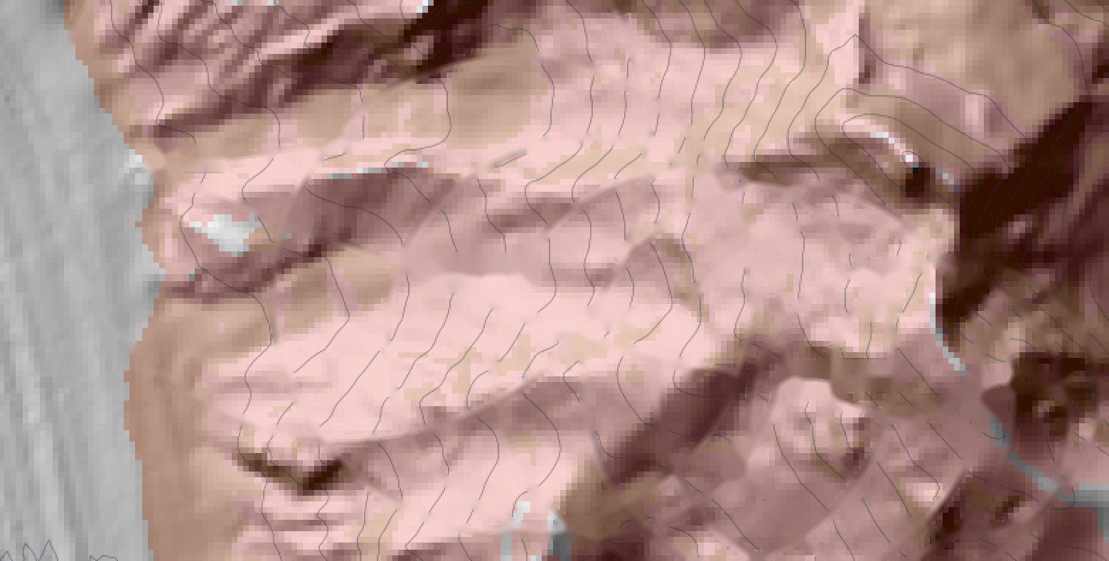
- Start zones, slopes of 30–55°
- Reached by frequent avalanches
- Route as the lab placed it
- Where the climbers were caught
- Where the avalanche ran, sketched
Three weeks of weather
The slopes between Camps 2 and 3, at 6,600 m, from 12 to 31 July. The levels are the site’s own model worked out again from the ECMWF forecasts archived at the time, and from ERA5, the reanalysis the site’s lab tests on. The new snow is the model’s, from the forecasts; the wind above the mountain and the freezing level are ERA5’s.
- 1 Low
- 2 Moderate
- 3 Considerable
- 4 High
- Tab: the level with the wind above the mountain, where higher
- Arrows: the way the wind blew
The week of snow
From 22 to 29 July the forecasts put about 32 cm of new snow on these slopes, and ERA5 about 36 cm, while ERA5’s south-west wind above the mountain blew at up to 41 km/h. The level rose to Considerable on 24–26 July (25–26 July on ERA5). The site’s free-air wind note, as it works now, would have shown High on 25 and 26 July, beside the level.
The day
On 30 July nothing fell, the wind above the mountain eased to 22 km/h from the west, and the forecasts had strong sunshine. On both the forecasts and ERA5 the level fell to Low. A level built from the weather falls as soon as the weather calms; a slab resting on a weak layer doesn’t heal that fast.
The crust
Before the week of snow, 15 to 21 July were dry and sunny by the forecasts, and ERA5’s freezing level rose no higher than 6,260 m, on 18 July, below the slopes. The windstorm reported on the night of 18 July doesn’t show in ERA5’s wind at 6,600 m, which stayed under 20 km/h from 14 to 21 July. Nor does the snowfall a rope-fixing team reported higher up on its summit push of 19 July: both the forecasts and ERA5 have no new snow at 6,600 m from 16 to 20 July.10 So the weather models couldn’t see the wind crust a climber found between Camps 2 and 3, and about 32 cm of new snow then fell on it.
| Day | Level, from the forecasts | With the wind above the mountain | Level on ERA5 | New snow | Since 22 July | Wind above the mountain |
|---|---|---|---|---|---|---|
| Wed 22 Jul | Moderate | no change | Low | 7.8 cm | 8 cm | 36 km/h from the south-west |
| Thu 23 Jul | Moderate | Considerable | Moderate | 8.2 cm | 16 cm | 41 km/h from the south-west |
| Fri 24 Jul | Considerable | no change | Moderate | 2.3 cm | 18 cm | 41 km/h from the south-west |
| Sat 25 Jul | Considerable | High | Considerable | 5.5 cm | 24 cm | 37 km/h from the south-west |
| Sun 26 Jul | Considerable | High | Considerable | 3.1 cm | 27 cm | 30 km/h from the south-west |
| Mon 27 Jul | Moderate | Considerable | Moderate | none | 27 cm | 27 km/h from the south-west |
| Tue 28 Jul | Moderate | no change | Moderate | 1.6 cm | 28 cm | 30 km/h from the south-west |
| Wed 29 Jul | Moderate | no change | Moderate | 3.2 cm | 32 cm | 23 km/h from the south-west |
| Thu 30 Jul, the avalanche | Low | no change | Low | none | 32 cm | 22 km/h from the west |
| Fri 31 Jul | Low | no change | Low | none | 32 cm | 15 km/h from the north-west |
What the site can and can’t see
The site’s level is the weather’s part in avalanche danger: new snow, wind, warmth and rain over the last few days, weighed by what the record of past avalanches shows. When the snow stops and the wind drops, the level drops too. What the weather leaves inside the snowpack, such as a slab resting on a crust or a weak layer, it can’t see.
So the site puts what people on the mountain see beside the level. A report of cracking, collapsing, a wind slab or a loaded slope, from a peak’s page, a radio check or a satellite messenger, keeps the point where it was made at Considerable or above for a week. A report of a loaded slope between Camps 2 and 3 on 25 July, say, would have kept those slopes at Considerable or above until 1 August.
Since November 2026, a crust reported the same way, with the code CRUST by satellite messenger, shows on the route as “Crust under new snow” once the model has 15 cm or more of new snow on it, for up to three weeks. Had a crust been reported at Camp 2 on 21 July, the note would have shown from 23 July, with about 16 cm on it, to 30 July, with about 32 cm. The note doesn’t change the level.
What the lab has tested since
This avalanche raised a question the site’s lab could test on the record: can the weather alone pick out the days after a storm when the level has dropped but a slab may still be ready to release? The rules for each test were written down before its first run, and Broad Peak was a check in each, never part of a fit.
- After the storm. Four rules marked the days after a storm. The strongest marked a day without new snow within three days of one at Considerable or above (a week while it stayed below −5 °C). In the Nepal record, the days it marked had 2.3 times the rate of snow-avalanche days of the days it didn’t (90% range 1.2–4.0). But around each avalanche, the avalanche day was marked no more often than the days near it (21% against 21%), so the rule can’t tell the dangerous day from the quiet ones beside it. The site’s old “After a storm” note did worse and was taken off. At Broad Peak every rule marked 30 July, and also between a third and two-thirds of the days either side.
- Buried crusts. Three rules marked new snow lying on a crust the weather had made: from melt or rain, from sun, or any crust, wind included. None passed. Crusts the model can see lay under the snow on only 6 of the 43 snow-avalanche days, and those days were no more dangerous than other days after the same storm. At Broad Peak the model found no crust at all: from 12 July on, its wind near the snow never passed 5 km/h, so it couldn’t make the wind crust the climber found.
- Accidents outside Nepal. Across 31 avalanche accidents on Pakistan’s 8,000 m peaks and Shishapangma, the site’s levels rank the accident days above the days around them: 0.62, where 0.50 is a typical day and 1.00 the highest. Broad Peak 2026 ranked 0.63, at Moderate, the higher of the day and the day before.
So the level still follows the weather alone: the record doesn’t show that holding it up after a storm would pick out the dangerous days. What the weather can’t see, the site takes from the people on the mountain.
Radar images
The lab also looked for the avalanche in Copernicus Sentinel-1 radar images, which see through cloud and pass over Broad Peak every few days. It couldn’t look at the place itself: the ground there is steeper than its method looks at, or hidden from the radar. Within 3 km of it, the last round marked about as many patches that brightened like debris between images taken before the avalanche (33) as between images either side of it (37). Three rounds of tests at Everest and Hispar, where others had mapped the debris by hand, found that more than 9 in 10 of the patches it marks fall where no debris was mapped, so the lab has set the radar aside. It can’t show where this avalanche ran.
How sure this is
- Places. The route points were placed by hand from route descriptions and moved by the terrain lab to ground of their height on a 30 m grid. Camp 2 moved about 700 m, so the marked area could be a few hundred metres off, and the gullies the avalanche ran down aren’t in the data. The elevation model’s makers filled in about three quarters of the ground between Camps 2 and 3 from another 30 m model, where their radar gave no height of its own.7 NASA’s laser altimeter crossed that ground on five dates, and nine in ten of its heights lie within about 20 m of the model’s.12
- Heights and times. They come from the climbers’ trackers as the press reported them. National Geographic notes that a tracker under snow or in steep ground can keep sending unreliable positions.2
- Weather. It comes from global models whose grid cells are about 9 to 30 km across, read at 6,600 m. Neither model shows the windstorm reported on 18 July or the snowfall reported higher up on 19 July, and no one measured the snow on these slopes.
- Levels. They are what the site’s current model makes of the forecasts archived at the time and of ERA5, not a record of what the site showed in July 2026.
- Examples. The crust note and the loaded-slope report above are examples. When the crust formed, and how far it reached, isn’t recorded.
Sources
- Wikipedia: 2026 Broad Peak avalanche. The date, time and height, the ten, the search and where the avalanche ran out.
- Anna Callaghan and Grayson Schaffer, How Nims Purja’s Himalayan climb ended in deadly disaster, National Geographic, 31 July 2026. The west-facing gully, the trackers’ times and heights, the snow from about 22 July, the climbers who left on 25 July.
- Angela Benavides, Broad Peak Avalanche: Two Bodies Found, Helicopters Search for Others, Explorersweb, 31 July 2026. The windstorm of 18 July and the wind crust between Camps 2 and 3, as a climber on the route reported them.
- Angela Benavides, What Happened on Broad Peak: The Latest Details About the Tragedy, Explorersweb, 10 August 2026. The four teams, the rib above Camp 3, the two gullies, the second avalanche during the search.
- Kris Annapurna, Sohail Sakhi’s Body Found on Broad Peak, Explorersweb, 13 August 2026. The climbers who left over the snow, the west-facing gully, falls of more than 1,500 m.
- Alan Arnette, Learnings from Broad Peak Tragedy, 13 August 2026. Four independent teams, days of heavy snow, the bergschrund.
- The site’s terrain lab, run of 10 November 2026, on the Copernicus DEM GLO-30 (© DLR e.V. 2010–2014 and © Airbus Defence and Space GmbH 2014–2018, provided under COPERNICUS by the European Union and ESA), with an energy-line runout model. The share of filled ground is from the model’s own quality layers, read on 19 November 2026.
- Weather: ECMWF IFS forecasts archived by Open-Meteo (CC BY 4.0); ERA5 from the Copernicus Climate Change Service, through Open-Meteo and on pressure levels from the Climate Data Store (contains modified Copernicus Climate Change Service information). The levels are the site’s model, v1.
- The site’s lab reports of November 2026: the checks after the storm and on buried crusts, the check outside Nepal, and the radar pilot’s three rounds. Radar: contains modified Copernicus Sentinel data 2026, processed by ASF DAAC HyP3 2026 using the GAMMA software.
- Alan Arnette, K2 2026: Summits on other 8000ers, Wind Stall K2 Summit Bids, 24 July 2026. A rope-fixing team’s own account of its summit push of 19 July: three days of work above Camp 3, waist-deep snow, snowfall on the push.
- Ryan Kushner, The slope on Broad Peak that Avalanched on Nims and others also avalanched in 2025!, YouTube, 31 July 2026. A film from base camp in 2025, as the weather cleared after a three-day storm.
- NASA ICESat-2 photon heights (ATL03, version 007), read through SlideRule Earth: the site’s laser check of 19 November 2026, within 150 m of the route point between Camps 2 and 3.